
Numerical Models
[1]
Real-time forecasting of solar radiation posses several benefits and has huge potential for industrial applications. However, the intermittent nature of solar radiation makes it difficult to forecast accurately. Cloud cover is one of the major influencing factors of solar radiation. Thus, forecasting cloud motion effectively can help to improve the accuracy of short-term solar radiation forecasts. In this study, a novel Multi-Layer Cloud Motion Vector (referred as 3D-CMV) forecasting technique was introduced, which combined with the fast radiative transfer model (FRTM) produces forecasts up to 3 h ahead at 15 min intervals over 5km 5km grids across Europe and North Africa. The cloud microphysics obtained from the Support to Nowcasting and Very Short Range Forecasting (SAFNWC) of the European Organisation for the Exploitation of Meteorological Satellites (EUMETSAT) was used as input to the forecasting system. The results obtained improvements in forecasts as compared to the conventional cloud motion vector techniques, across all seasons and sky conditions. Comparisons against ground-based measurements from the Baseline Surface Radiation Network (BSRN) revealed an overall maximum percentage difference of less than 12%, bias under -20 Wm−2 and a root mean square error (RMSE) under 80 Wm−2. Performance evaluations of Multi-Layer Cloud Motion Vector has been performed against several state-of-the-art techniques and presented in this study. Short-term solar energy forecasting has an established market and rising demand. Accurate forecasts from Multi-Layer CMV hence pose a high potential for real world applications.
[2]

This study focuses on the assessment of surface solar radiation (SSR) based on operational neural network (NN) and multi-regression function (MRF) modelling techniques that produce instantaneous (in less than 1 min) outputs. Using real-time cloud and aerosol optical properties inputs from the Spinning Enhanced Visible and Infrared Imager (SEVIRI) on board the Meteosat Second Generation (MSG) satellite and the Copernicus Atmosphere Monitoring Service (CAMS), respectively, these models are capable of calculating SSR in high resolution (1 nm, 0.05∘, 15 min) that can be used for spectrally integrated irradiance maps, databases and various applications related to energy exploitation. The real-time models are validated against ground-based measurements of the Baseline Surface Radiation Network (BSRN) in a temporal range varying from 15 min to monthly means, while a sensitivity analysis of the cloud and aerosol effects on SSR is performed to ensure reliability under different sky and climatological conditions. The simulated outputs, compared to their common training dataset created by the radiative transfer model (RTM) libRadtran, showed median error values in the range −15 to 15 % for the NN that produces spectral irradiances (NNS), 5–6 % underestimation for the integrated NN and close to zero errors for the MRF technique. The verification against BSRN revealed that the real-time calculation uncertainty ranges from −100 to 40 and −20 to 20 W m−2, for the 15 min and monthly mean global horizontal irradiance (GHI) averages, respectively, while the accuracy of the input parameters, in terms of aerosol and cloud optical thickness (AOD and COT), and their impact on GHI, was of the order of 10 % as compared to the ground-based measurements. The proposed system aims to be utilized through studies and real-time applications which are related to solar energy production planning and use.
[3]
This study introduces an Earth observation (EO)-based system which is capable of operationally estimating and continuously monitoring the ultraviolet index (UVI) in Europe. UVIOS (i.e., UV-Index Operating System) exploits a synergy of radiative transfer models with high-performance computing and EO data from satellites (Meteosat Second Generation and Meteorological Operational Satellite-B) and retrieval processes (Tropospheric Emission Monitoring Internet Service, Copernicus Atmosphere Monitoring Service and the Global Land Service). It provides a near-real-time nowcasting and short-term forecasting service for UV radiation over Europe. The main atmospheric inputs for the UVI simulations include ozone, clouds and aerosols, while the impacts of ground elevation and surface albedo are also taken into account. The UVIOS output is the UVI at high spatial and temporal resolution (5 km and 15 min, respectively) for Europe (i.e., 1.5 million pixels) in real time. The UVI is empirically related to biologically important UV dose rates, and the reliability of this EO-based solution was verified against ground-based measurements from 17 stations across Europe. Stations are equipped with spectral, broadband or multi-filter instruments and cover a range of topographic and atmospheric conditions. A period of over 1 year of forecasted 15 min retrievals under all-sky conditions was compared with the ground-based measurements. UVIOS forecasts were within ±0.5 of the measured UVI for at least 70 % of the data compared at all stations. For clear-sky conditions the agreement was better than 0.5 UVI for 80 % of the data. A sensitivity analysis of EO inputs and UVIOS outputs was performed in order to quantify the level of uncertainty in the derived products and to identify the covariance between the accuracy of the output and the spatial and temporal resolution and the quality of the inputs. Overall, UVIOS slightly overestimated the UVI due to observational uncertainties in inputs of cloud and aerosol. This service will hopefully contribute to EO capabilities and will assist the provision of operational early warning systems that will help raise awareness among European Union citizens of the health implications of high UVI doses.

[5]
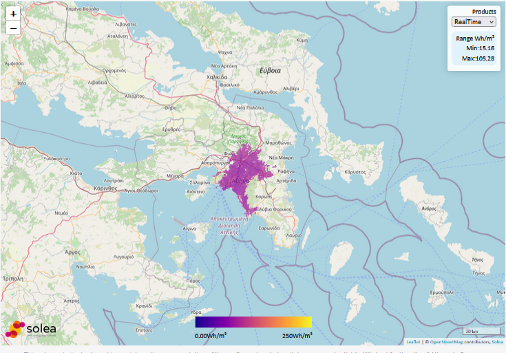
This solar cadastre tool provides an interactive representation of the rooftop solar photovoltaic energy potential (in Wh/m2) for the city of Athens in Greece.
It simulates the three-dimensional ray tracing and shadow casting in a hybrid mode (real-time & climatological) for smart energy distribution management and urban planning by exploiting Copernicus and SAFNWC data, fast radiative transfer models, advanced graphic creation platforms and cloud supercomputing.


[6]
The present study focuses on the predictions and verification of these predictions of solar energy using ground-based solar measurements from the Hellenic Network for Solar Energy and the National Observatory of Athens network, as well as solar radiation operational forecasts provided by the MM5 mesoscale model. The evaluation was carried out independently for the different networks, for two forecast horizons (1 and 2 days ahead), for the seasons of the year, for varying solar elevation, for the indicative energy potential of the area, and for four classes of cloud cover based on the calculated clearness index (kt): CS (clear sky), SC (scattered clouds), BC (broken clouds) and OC (overcast). The seasonal dependence presented relative rRMSE (Root Mean Square Error) values ranging from 15% (summer) to 60% (winter), while the solar elevation dependence revealed a high effectiveness and reliability near local noon (rRMSE ∼30%). An increment of the errors with cloudiness was also observed. For CS with mean GHI (global horizontal irradiance) ∼ 650 W/m2 the errors are 8%, for SC 20% and for BC and OC the errors were greater (>40%) but correspond to much lower radiation levels (<120 W/m2) of consequently lower energy potential impact. The total energy potential for each ground station ranges from 1.5 to 1.9 MWh/m2, while the mean monthly forecast error was found to be consistently below 10%.
[7]
The rapid growth in the use of Solar Energy for sustaining energy demand around the world requires accurate forecasts of Solar Irradiance to estimate the contribution of solar power to the power grid. Accurate forecasts for higher time horizons help to balance the power grid effectively and efficiently. Traditional forecasting techniques rely on physical weather parameters and complex mathematical models. However, these techniques are time-consuming and produce accurate results only for short forecast horizons. Deep Learning Techniques like Long Short Term Memory (LSTM) networks are employed to learn and predict complex varying time series data. However, LSTM networks are susceptible to poor performance due to improper configuration of hyperparameters. This work introduces two new algorithms for hyperparameter tuning of LSTM networks and a Fast Fourier Transform (FFT) based data decomposition technique. This work also proposes an optimised workflow for training LSTM networks based on the above techniques. The results show a significant fitness increase from 81.20% to 95.23% and a 53.42% reduction in RMSE for 90 min ahead forecast after using the optimised training workflow. The results were compared to several other techniques for forecasting solar energy for multiple forecast horizons.